|
Tornado is the most violent of all storms. A tornado, sometimes called a twister, consists of a rapidly rotating column of
air that forms under a thundercloud or a developing thundercloud. Tornado winds swirl at speeds that may exceed 300 miles
(480 kilometers) per hour. A powerful tornado can lift cattle, automobiles, and even mobile homes into the air and destroy
almost everything in its path. Fortunately, most tornadoes are relatively weak, and only a few are devastating.
Scientists use the word cyclone to refer to all spiral-shaped windstorms that circulate in a counterclockwise direction
in the Northern Hemisphere or in a clockwise direction in the Southern Hemisphere. The term cyclone comes from the Greek word
for circle. Cyclones come in many sizes. Among the largest such storms are hurricanes and typhoons, which may reach 250 miles
(400 kilometers) across.
Most tornadoes are small, intense cyclones. On rare occasions, the winds whirl in the direction opposite that of a cyclone--for
example, clockwise in the Northern Hemisphere.
Most tornadoes have damage paths less than 1,600 feet (500 meters) wide, move at less than 35 miles (55 kilometers) per
hour, and last only a few minutes. Extremely destructive twisters may reach 1 mile (1.6 kilometers) in diameter, travel at
60 miles (100 kilometers) per hour, and blow for more than an hour.
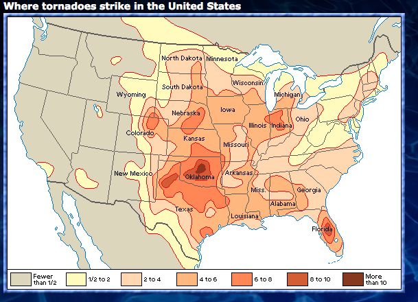
The United States has the highest incidence of tornadoes in the world. Most of these storms occur in a belt known as Tornado
Alley that stretches across the Midwestern and Southern states, especially Texas, Oklahoma, Kansas, Nebraska, and Iowa. However,
tornadoes also strike many other parts of the world. Australia ranks second to the United States in number of twisters, and
many damaging tornadoes strike Bangladesh. Tornadoes occur most often during the spring and early summer in the late afternoon
and early evening.
A tornado over a body of water is called a waterspout. Waterspouts occur frequently in summer over the Florida Keys. Waterspouts
also form elsewhere in the Gulf, along the Atlantic and Pacific coasts, over the Great Lakes, and even over the Great Salt
Lake in Utah.
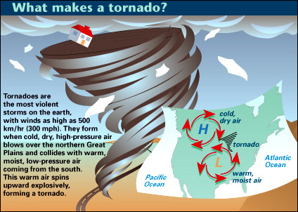
The story of a tornado. The majority of tornadoes develop from severe thunderstorms. A hurricane, when it makes landfall,
can also generate tornadoes.
The most damaging tornadoes form in large, powerful thunderstorms called supercells. For a supercell to form, and perhaps
spawn a tornado, several conditions must exist. There must be an adequate supply of moisture to feed the storm. In Tornado
Alley, air from the Gulf of Mexico provides the moisture. There must be a layer of warm, moist air near the ground and a layer
of much cooler air above. Often, a front (the boundary between two air masses at different temperatures) powers an upward
flow of warm air. As the warm air rises, it begins to cool, and the moisture it holds condenses into raindrops. The air stops
rising at high levels and spreads sideways to form a characteristic anvil-shaped storm cloud.
For a supercell to develop, the winds at higher elevations must differ markedly from those at lower levels in speed, direction,
or both. Such a large difference in wind speed or direction is called wind shear. Wind shear makes the column of rising air
begin to rotate, forming a broad, horizontal tube of swirling air. As the storm continues, this tube turns on its end, producing
a rotating column of air called a mesocyclone. Studies show that most supercells containing mesocyclones eventually produce
tornadoes.
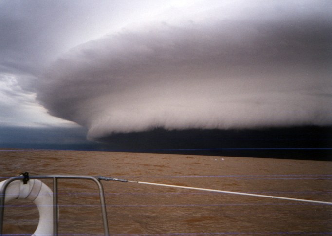
A low, dark, heavy cloud called a wall cloud forms underneath the mesocyclone. Tornado funnels develop out of the wall
cloud.
The first sign of an approaching tornado may be light rain, followed by heavier rain, then rain mixed with hail. The hailstones
may grow to the size of golf balls or even baseballs. After the hail ends, a tornado may strike. In most tornadoes, a funnel-shaped
cloud forms and descends from the wall cloud until it touches the ground. However, there might be a tornado even if the funnel
does not touch the ground or if the air is too dry for a funnel cloud to form. Sometimes, the first sign of a tornado is dust
swirling just above the ground.
A few small tornadoes begin near the ground and build upward with no apparent connection to the storm aloft. Many of these
storms occur without mesocyclones and lack a funnel cloud.
Damage by tornadoes. Most tornado damage results from the force of the wind. Each time the wind speed doubles, the force
of the wind increases four times. For example, the force of the wind at 220 miles per hour is four times as great as the force
at 110 miles per hour. This tremendous strength may knock over buildings and trees. Other damage occurs when the wind picks
up objects and hurls them through the air.
Scientists estimate the wind speed of a tornado by the damage it inflicts, using a gauge called the Fujita scale. The
scale was developed by the Japanese-born weather scientist T. Theodore Fujita. On the Fujita scale, F0 is the weakest rating
and F5 is the strongest. An F5 tornado can remove a house from its foundation.
A tornado sucks up air when passing over a building. For this reason, some people think they should open windows to help
equalize the pressure if a tornado threatens. They fear that the air pressure outside the building might drop so suddenly
that the structure would explode outward. Safety experts know, however, that air moves in and out of most buildings so quickly
that air pressure remains nearly equal inside and out, even during a tornado. Open windows do not reduce damage and may even
increase it because wind blowing in may hurl loose objects through the air.
Tornado damage is often localized. A tornado may demolish one house and leave an adjacent house untouched.
Some tornadoes consist of smaller rotating columns of air called suction spots or suction vortices. The suction spots
revolve around the central axis of the tornado and can inflict tremendous damage to small areas.
Forecasting tornadoes. Meteorologists (scientists who study weather) can predict possible severe weather 12 to 48 hours
in advance. They make such forecasts using data from weather balloons, satellites, and conventional weather radar. Computers
help meteorologists analyze the data and recognize when conditions favor the formation of thunderstorms.
Meteorologists use a special type of radar called Doppler radar to look for mesocyclones. This type of radar works because
radar waves change frequency depending on whether the objects they bounce off, such as raindrops or dust particles, are advancing
or receding. This change in frequency, called the Doppler effect, can reveal the rotating pattern of a mesocyclone.
In the United States, the National Weather Service issues a tornado watch when conditions in the atmosphere promote the
formation of tornadoes. If a tornado watch is issued for your area, you should watch for threatening weather and listen to
the radio or television for more information.
If Doppler radar detects a mesocyclone in a thunderstorm, the National Weather Service issues a tornado warning. The Weather
Service also issues a tornado warning if someone actually sees a funnel cloud. If a tornado warning is issued for your location,
take cover immediately. The safest place is a basement or other underground shelter. If no underground shelter is available,
an interior bathroom or closet is best.
Studying tornadoes. Meteorologists study tornadoes both outdoors and in the laboratory. Tornadoes are difficult to study
outdoors because they form and vanish quickly and occupy a small area. Another problem is that scientists do not know exactly
what causes tornadoes, so they find it difficult to get to the right place at the right time to gather data.
Many meteorologists form mobile teams of "storm chasers" to study tornadoes outdoors. The storm chasers travel
in specially equipped automobiles, vans, trucks, and aircraft, trying to get near tornadoes without coming too close. The
researchers drop instruments in or near the paths of tornadoes to measure wind, temperature, and air pressure. They also record
flying debris on film or videotape so they can analyze wind patterns. Doppler radar enables storm chasers to map wind speed
and direction and to study the changes that take place in a thunderstorm before a tornado forms.
Meteorologists make computer models (mathematical representations) of thunderstorms and tornadoes. They also simulate
tornadoes using rotating air currents in chambers. Scientists hope to learn why tornadoes form, to know what happens inside
a tornado, and to better forecast these destructive storms.
Contributor: Howard B. Bluestein, Ph.D., Professor of Meteorology, School of Meteorology, University of Oklahoma.
|